Gallery
 PM Modi visit USA
 Only the mirror in my washroom and phone gallery see the crazy me : Sara Khan
 Karnataka rain fury: Photos of flooded streets, uprooted trees
 Cannes 2022: Deepika Padukone stuns at the French Riviera in Sabyasachi outfit
 Ranbir Kapoor And Alia Bhatt's Wedding Pics - Sealed With A Kiss
 Oscars 2022: Every Academy Award Winner
 Shane Warne (1969-2022): Australian cricket legend's life in pictures
 Photos: What Russia's invasion of Ukraine looks like on the ground
 Lata Mangeshkar (1929-2022): A pictorial tribute to the 'Nightingale of India'
 PM Modi unveils 216-feet tall Statue of Equality in Hyderabad (PHOTOS)
The Badminton Association of India (BAI) has announced a 14-member-strong India squad for
- Men’s Sr Hockey Nationals to be played in division-based format from April 4
- Mensik denies Djokovic 100th title in Miami final
- KIPG: Son of a vegetable vendor, Bihar’s Jhandu Kumar eyes Worlds, 2028 Paralympics
- Hardik Singh credits hard work and team unity for receiving HI Midfielder of the Year award
- Djokovic, Alcaraz land in same half of Miami draw
NASA satellite data helps track ocean microplastics from space Last Updated : 27 Jun 2021 12:23:35 AM IST 
Scientists from the University of Michigan have developed an innovative way to use NASA satellite data to track the movement of tiny pieces of plastic in the ocean.
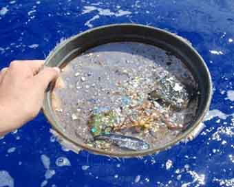
Microplastics form when plastic trash in the ocean breaks down from the sun's rays and the motion of ocean waves. These small flecks of plastic are harmful to marine organisms and ecosystems.Microplastics can be carried hundreds or thousands of miles away from the source by ocean currents, making it difficult to track and remove them.Currently, the main source of information about the location of microplastics comes from fisher boat trawlers that use nets to catch plankton - and, unintentionally, microplastics.The new technique relies on data from NASA's Cyclone Global Navigation Satellite System (CYGNSS) -- a constellation of eight small satellites that measures wind speeds above Earth's oceans and provides information about the strength of hurricanes. CYGNSS also uses radar to measure ocean roughness, which is affected by several factors including wind speed and debris floating in the water.Working backward, the team looked for places where the ocean was smoother than expected given the wind speed, which they thought could indicate the presence of microplastics.Then they compared those areas to observations and model predictions of where microplastics congregate in the ocean. The scientists found that microplastics tended to be present in smoother waters, demonstrating that CYGNSS data can be used as a tool to track ocean microplastic from space.IANS New York For Latest Updates Please-
Join us on
Follow us on


172.31.16.186


